A 699-home master-planned village at 207 Broulee Road, currently lodged with Eurobodalla Shire Council.
At 207 Broulee Road, between the township and the bush. A site of paddocks and remnant eucalypt forest, sitting on a low ridge that runs roughly east–west and opens out to a long view toward Broulee Island and the Tasman Sea.
It’s bordered by Broulee Road to the south, George Bass Drive to the east, Carroll College across the road, and a band of native bushland along the north and west. The ridge has been farmland for generations. The bush along the boundaries has been undisturbed for longer.
The masterplan starts with what’s here. The conservation areas trace the existing vegetation. The roads follow the natural contours. The homes sit where they best catch the view without taking it from anyone else.
The masterplan was drawn by URBANEW in response to the site’s three defining features — the ridgeline, the native vegetation, and the distance to existing services. What follows is the plan as lodged with Eurobodalla Council in December 2025.
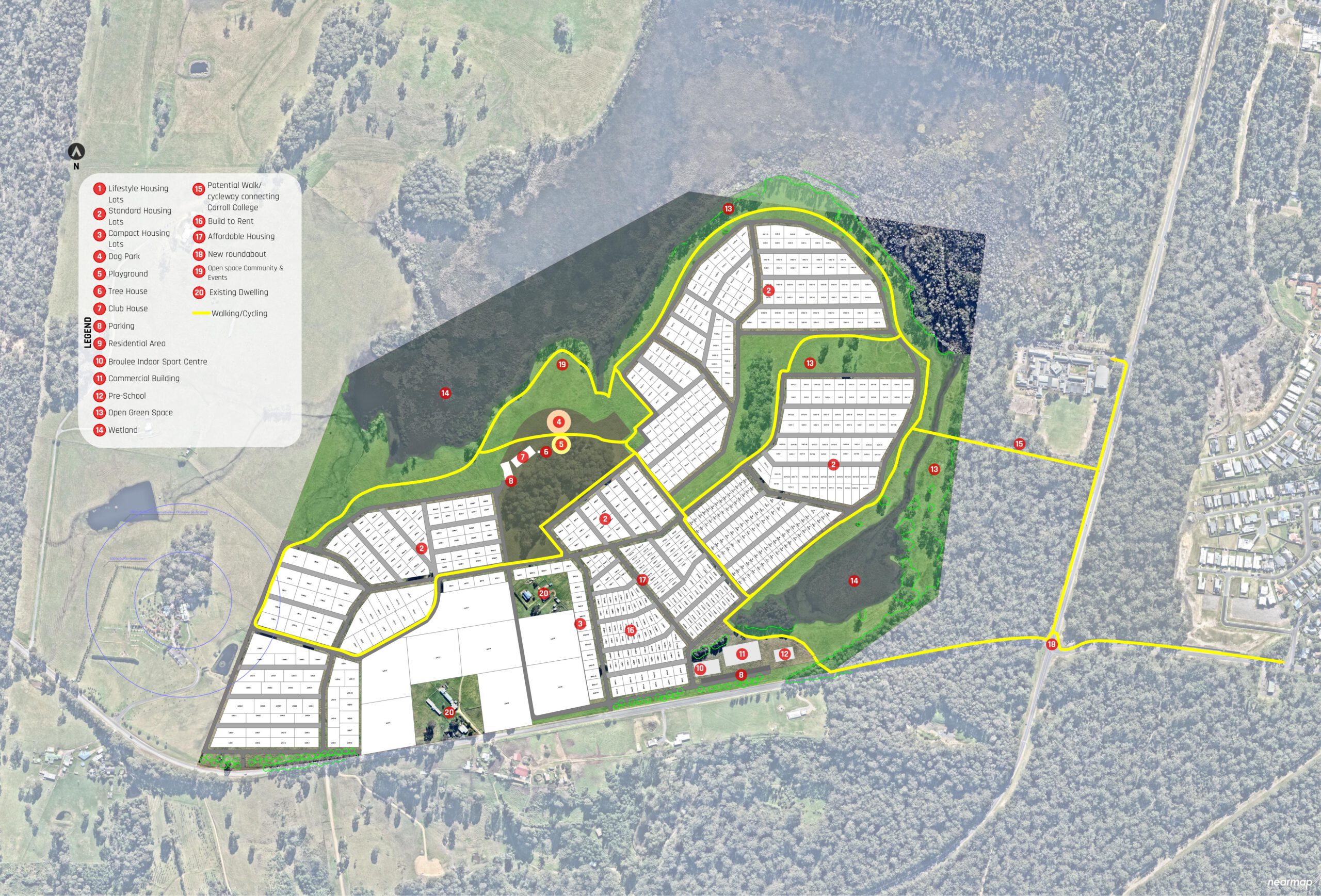
Five housing types, distributed across the site to support different stages of life and different incomes.
The design didn’t start with how many homes could fit. It started with what shouldn’t change.
The native vegetation along the north, west, and south of the site is preserved before any lots are drawn. About 32 hectares — a third of the site — remain as conservation land, managed for biodiversity and connected by trails rather than cut by roads.
The trail network runs through the village rather than around it. From most homes, the schools are walkable, the bush is walkable, and the township is a short ride. The car is for elsewhere, not the everyday.
A single development that supports families through different stages, downsizers staying in the area, key workers needing rental close to work, and young households trying to enter the market. Five housing types in one village, by design.
Five per cent of homes stay affordable in perpetuity. Five per cent are rental housing reserved for key workers. The Key Worker Finance Scheme runs alongside, helping young families into ownership. These aren’t temporary marketing positions; they’re conditions written into the titles.
The site borders rural properties, a school, a road, and a crematorium. Each edge is treated differently — native planting strips, conservation buffers, set-back built form — so the village reads as part of the landscape rather than imposed on it.
Five per cent of the 699 homes — around 35 — will be sold at below-market price to qualifying buyers. The affordability condition is built into the title, which means the next sale stays affordable too. Same for the sale after that. The homes don’t leak out of the affordable pool over time, which is what happens to most affordable housing inside a decade.
Another 5% — also around 35 — are built as long-term rental housing reserved for key workers. Nurses, teachers, paramedics, and the doctors at the new Moruya Hospital who need housing close to where they work. Rents are pegged to local key-worker wages, not the open market.
Alongside is a Key Worker Finance Scheme, designed to help young families and key workers into ownership where the deposit gap has put a home out of reach. [Details to follow once finalised.]
It’s a smaller commitment in dollar terms than the rest of the development. It’s a bigger commitment in time. The conditions written into the titles outlive everyone involved in writing them. We think that’s the right way for a village to start.
About a third of the site — 32 hectares of native eucalypt forest, banksia heath, and remnant coastal vegetation — is set aside as conservation land. Not as buffers retrofitted after the lots were drawn, but as the starting condition the masterplan was built around.
The conservation areas remain connected to the bushland beyond the site boundary. Trails through them are designed to minimise edge effects on the vegetation. Native planting strengthens the corridor over time. Water management mimics the existing drainage rather than diverts it.
Broulee Ridge is currently at the rezoning stage. Eurobodalla Shire Council is reviewing the proposal, and the community has a formal window to make submissions before any decision is made. Brightway is running its own engagement alongside the formal process — info sessions, on-site conversations, and a place to ask questions or tell us where we’ve got it wrong.
The plan isn’t locked. Your input changes it.
The masterplan was drawn by URBANEW. The proposal is by Brightway Development Group — sibling to Talee Estate, Brook Village, and the Legacy Housing Pledge.
As the project moves through Council and beyond, we’ll share:
Roughly six emails a year while we’re at the consultation stage. More if there’s something worth saying.
We’ll email occasional updates on the project. We won’t share your details. You can unsubscribe at any time.